PRIYADARSHINI JURALA PROJECT
Preamble
The Priyadarshini Jurala Project or Jurala Project is situated about 10 km from Kuravapur, Mahbubnagar district, Telangana, India. It is constructed on the Krishna river. The Kurvapur Kshetra River is merging with water of the Joorala Project. The project foundation stone laid by Smt.PRIYADARSHINI INDIRA GANDHI for the welfare of district. The Jurala has a full reservoir level of 1045 ft and has a full capacity of 11.94 TMC. As of August 2013, the project has an estimated capacity of 9.74 TMC. The Jurala Project was completed in 1995
Irrigation: 1,04,774 acres through Left and Right main canals in Mahabubnagar district. 6,824 ac under Ramanpad (Ookachetti Vagu) balancing reservoir through PJP LMC. Supplementation to 30,000 ac tailend ayacut of RDS through PJP RMC / Link Canal. Source for Jawahar Nettempadu Lift Irrigation Project (JNLIP) – 2,00,000 ac Source for Rajiv Bhima Lift Irrigation Project (RBLIP) – 2,00,000 ac Source for Koilsagar Lift Irrigation Project (KSLIP) – 50,250 ac
Power: 234 MW utilizing surplus water (Priyadarshini Jurala Hydro Electric Project)
Salient Features
| LOCATION: | ||
| State | : | Telangana |
| District | : | Revulapally (v), Dharoor (M), Mahabubnagar (D) |
| Latitude | : | 160 20' 15" N |
| Longitude | : | 770 42' 15" E |
| Catchment area | : | 1,29,499 Sq Km (50,000 Sq miles)(Maharashtra 54%; Karnataka 43%; Telangana 3%) |
| Designed Max flood discharge | : | 35,396 cumecs (12.50 lakh cusecs) |
| Net dependable yield | : | 10,930 M Cum (386 TMC) |
| KWDT allocation | : | 505.17 M Cum (17.84 TMC out of 800 TMC allocated to AP) |
| BARRAGE (Composite structure with stone masonry & cement concrete) | ||
| FRL / MWL | : | +318.516 mt (+1045.00 ft) |
| MDDL | : | +314.858 mt (+1033.00 ft) |
| Sill level of LMC & RMC | : | +312.420 mt (+1025.00 ft) |
| Crest level | : | +310.000 mt |
| Road Level / total width / clear road way | : | +325.000 mt / 8.40 mt / 5.30 mt |
| Hoist platform level | : | +328.900 mt |
| Max tail water level for 12.50 lakh cusecs | : | +312.030 mt |
| Average bed level of Krishna / deepest | : | +301.360 mt / +297.800 mt |
| Average foundation level / deepest | : | +294.000 mt / +285.000 mt |
| Gross storage at FRL / MWL | : | 338.13 M Cum (11.941 TMC) |
| Live storage (above MDDL) | : | 192.50 M Cum ( 6.798 TMC) |
| Dead storage (below MDDL) | : | 145.63 M Cum ( 5.143 TMC) |
| Storage above crest level of 310.000 mt | : | 309.19 M Cum (10.919 TMC) |
| Water spread area at FRL/ MWL | : | 67.68 Sq km (16,724 acres) including river course |
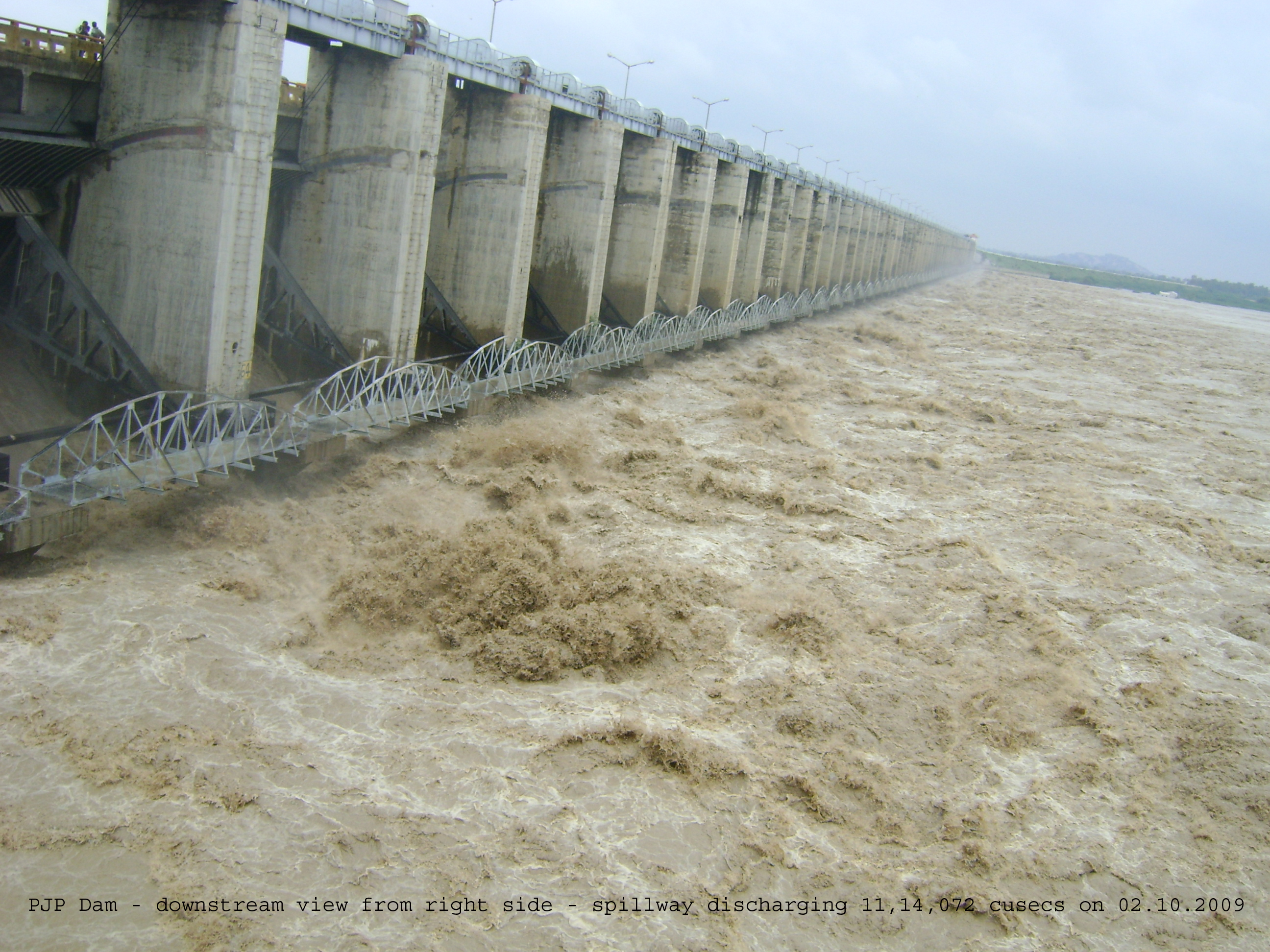
| Length of barrage between abutments | : | 1322 mt (spill way 927 mt & power blocks 162 mt) |
| No. & Size of spillway gates | : | 62 radial gates of size 12 mt x 8.516 mt |
| Drainage gallery | : | 1.50 x 2.25 mt |
| EARTH DAM: | ||
| Length of earth dam | : | Left side 1.74 Km; Right side 1.47 Km |
| TBL of Earth Dam | : | +321.500 mt (+1054.79 ft) |
| Free board | : | 2.984 mt (9.79 ft) |
| Top width of Earth dam / clear road way | : | 8 mt / 6.40 mt |
| HEAD REGULATORS: | ||
| LMC H/R @ km 0.520 | RMC H/R @ km 3.720 | |
| No of vents and size | 4 Nos of 2.5 x 2.0 mt | 4 Nos of 1.5 x 2.0 mt |
| Sill Level | +312.420 m (+1025.00 ft) | +312.420 m (+1025.00 ft) |
| Discharge | 41.34 cumecs (1460 cusecs) | 20.80 cumecs (735 cusecs) |
| MAIN CANALS: | ||
| LMC (NTR canal) | RMC (Nala Somanadri canal) | |
| Bed width / FSD (initial reach) | 21.00 mt / 1.95 mt | 9.75 mt / 1.90 mt |
| Bed fall | 1 in 9,000 | 1 in 5,800 & 1 in 14,000 |
| Length of canal | 85.277 km | 46.275 km |
| Ayacut | 69,117 ac | 35,657 ac |
| Mandals benefited | Atmakur, Kothakota, Pebberu, Weepanagandla & Kollapur | Gadwal, Dharur, Itikyala & Manopadu |