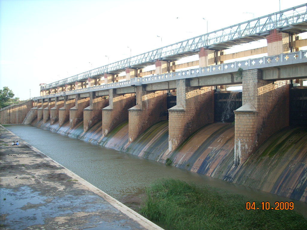
BHAIRAVANITIPPA RESERVOIR PROJECT

Preamble
The Bhairavanithippa project was constructed across Pedda hagari (Vedavathi) river at Bhairavanithippa (V) in Gummagatta (M) in the year 1961 at an estimated cost of Rs.1,43,75,000/- The hagari river which is a tributary of Tungabhadra river takes its origin in the Baba budamagiri range hills of the western ghats in Karnataka state and flows in the territory for a length of 138 miles and enters into Andhra Pradesh state. This project is located at 1.50 km below Andhra Pradesh border.
The Karnataka state Government constructed a dam called Vani vilas sagar project at about 68 miles upstream of B T Project with a storage capacity of 850 M cum(30.025 TMC). The B T Project was designed taking in to consideration of yield from catchment area of 14,386 sq kms located in between vani vilas sagar project and B T Project. The river hagari runs for another 170 kms below the project and joins the Tungabhadra river at Siriguppa village in Karnataka State.
The B T Project was designed to irrigate 12,000 acres (4856 Ha) through two canals located on either side of reservoir. The left flank main canal (LFMC) is designed for a discharging capacity of 5.125 cumecs (181 cusecs) and the canal runs 25 kms length to serve an ayacut of 8240 acres (3334 Ha) through 22 sluices and feeds three tanks namely 1. K V Tank 2. Kalugodu tank 3 Basetty tank. The right flank main canal (RFMC) is designed for a discharging capacity of 2.35 cumecs (83 cusecs) and the canal runs for a length of 13.80 kms to serve an ayacut of 3760 acres(1522 ha) spread over in 14 villages in Brahmasamudram mandal through 16 sluices and 8 direct pipes having an ayacut less than 40 ha under each of them.
The modernization of Bhairavanithippa project was proposed with financial assistance of Japan International Co Operatiion Agency (JICA) Phase II Programme to take necessary steps for improving the canals and distributory system by doing lining and restoration. The estimate for the above work was technically sanctioned by the Engineeer-in Chief, medium Irrigation, Hyderabad vide CE(I) No 02/2011-12 dated 02-05-2011 for Rs 1482.47 lakhs. Tenders were invited and C O T was also approved in favour of M/S H.E.S infra Pvt. Ltd., Hyderabad who has quoted at 2.79% excess over the ECV of Rs 13,80,69,527/- and TCV of Rs 14,19,21,666/- . The agreement was concluded on 16-02-2012, vide agt. No 24 SEA/2011-12.
Approximately 60% of work is completed and now the work is in 3rd extention of time and is scheduled to be completed by December 2015.
Salient Features
| Location | : | The project is constructed across Vedavathi river near Bhairavanitippa (V), Gummagatta (M), Ananthapur District. |
| Location | : | Gummagatta(M), Anantapur Dist (A.P) |
| Latitude | : | 14° 32'10"N |
| Longitude | : | 76° 50'30"E |
| Catchment area | : | 5557 Sq miles (14386 Sq kms) |
| Intercepted | : | 2075 Sq miles (5372 Sq kms) |
| Free | : | 3482 Sq miles (9014 Sq kms) |
| Ayacut | : | 12000 acres (4856 Ha) |
| Length of Dam | : | 2198 M |
| Top width of bund | : | 5.48 M (18.00 ft) |
| Area of submergence at FRL | : | 15.475 Sq. Km/5.975 Sq miles |
| TBL | : | 506.550M (+1662.00 ft) |
| FRL | : | 504.440M (+1655.00 ft) |
| Maximum water Level | : | 504.440M (+1655.00 ft) |
| Sill Level of Irrigation Sluices | : | +497.740 M Left side +497.740 M Right side |
| Maximum Flood Discharge | : | 1,28,360cusecs (3639 Cumecs) |
| Spillway Crest Level | : | 499.872M (+1640.00 ft) |
| No. and size of Gates | : | 12 No of Vertical gates of 40 ft. x 15 ft. |
| No. and size of Scour Gates | : | 2 No of size 16 ft. x 10 ft. |
| Gross storage | : | 2001.05 Mcft (56.6647 M Cum) |
| Live storage | : | 1963.23 Mcft (55.5936 M cum) |
| Left canal Discharge at head | : | 181 cusecs (5.124 Cumecs) |
| Right canal Discharge at head | : | 83 cusecs (2.35 Cumecs) |
| Left canal vent size | : | 5.0x5.0 ft |
| Right canal vent size | : | 2.5x4.0 ft |
| Maximum Height of Dam | : | 16.50 M(54.00 ft) |
| Left canal bed fall | : | 1ft per 1 mile |
| Right canal bed fall | : | 1.5ft per 1 mile |
| Length of left canal | : | 25.00 Kms |
| Length of right canal | : | 13.80 Kms |
| Ayacut under LFMC | : | 8240 acres |
| Ayacut under RFMC | : | 3760 acres |
| Rate of sedimentation | : | 0.398 Ha m/100 sq km/Year |
| Mandals benefited | : | Gudimetta , Bhramhasamudram |