SANJEEVIAH SAGAR Gajuladinne Project
Preamble
The Gajuladinne Project (GDP) renamed as Sanjeevaiah Sagar, is a Medium Irrigation Project constructed across Hundri, a tributary to Tungabhadra in Krishna basin near Gajuladinne village in Gonegandla Mandal of Kurnool District. The location of the scheme corresponds to longitude 77°37’20”E and Latitude 15°41’48”N. The Hundri takes its origin in Pathikonda hills and travels 130 kms before it joins Tungabhadra. The flow in the river is dry except during monsoon.
The GDP provides irrigation facility to 25,454 acres of ID crops in Rabi. The project serves 21 villages in four mandals of Kurnool District viz., Gonegandla (9 nos), Kodumur (5 nos), Krishnagiri (6 nos), and Devanakonda (1no.). The WUA Project committee is formed with 2 WUAs in LMC and 10WUAs in RMC.
The project was taken up for execution during 1971 and completed by 1987 at a cost of Rs 263 lakh. The project is constructed with a storage capacity of 4.50 TMCft at FRL of + 377.000 M.
Salient Features
| LOCATION: | ||
| Location | : | Kurnool Dist., Andhra Pradesh |
| Latitude | : | 15-41-48 N |
| Longitude | : | 77-37-20 E |
| METEOROLOGICAL DATA | ||
| Mean Annual Rainfall Maximum | : | 939.30 mm |
| Mean Annual Rainfall Minimum | : | 240.10 mm |
| HYDROLOGY | ||
| Catchment Area | : | 1,274 sq km (492 sq. miles) |
| Full reservoir level | : | 377.000 M |
| Maximum water level | : | 378.000 M |
| Top of bund level | : | 379.500 M |
| Spill way crest level | : | 371.000 M |
| Deepest river bed level | : | 363.000 M |
| Minimum draw down level | : | 367.200 M |
| Water spread area at FRL | : | 27.050 Sq.Kms |
| Water spread area at MWL | : | 31.970 Sq.Kms |
| STORAGE CAPACITIES | ||
| Gross Storage at FRL | : | 4.500 TMC |
| Gross Storage at MWL | : | 5.250 TMC |
| Gross Storage at MWL | : | 5.250 TMC |
| Live Storage at FRL | : | 4.050 TMC |
| Spillway crest level | : | 0.800 TMC |
| MDDL | : | 0.200 TMC |
| EARTH DAM | ||
| Length of bund | : | 4.313 Km |
| Maximum Height | : | 9.50 m |
| Top width | : | 5.00 m |
| Top Level | : | +379.500 m |
| Side slopes U/S | : | 2:5:1 |
| Side slopes D/S | : | 2:1 |
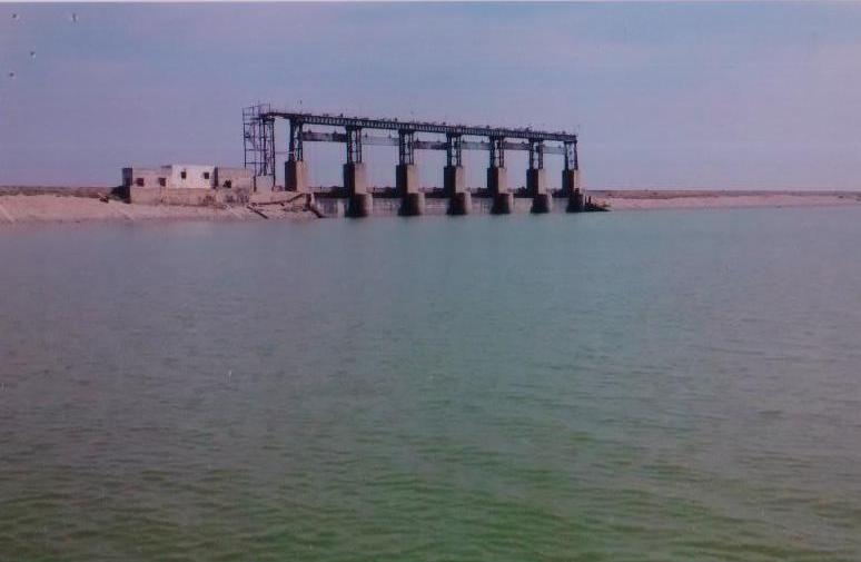
| SPILLWAY OF DAM | ||
| Length | : | 87.00 m |
| Maximum height | : | 18.30 m |
| Top of shutters level | : | +378.350 m |
| Hoist platform level | : | +382.000 m |
| No. and type of gates | : | 6 nos. Vertical |
| Size of gates | : | 12.00 m X 7.35 m |
| CANALS AND COMMAND AREA | |||
| Name of the Canal | Sill level of sluice | length in Km | Localized ayacut in acres |
| Right side canal | +367.200 m | 36.0 | 21,703 |
| Left side canal | +367.500 m | 26.0 | 3,751 |
| Total | 25,454 | ||