NEELAM SANJEEVA REDDY SRISAILAM PROJECT
Preamble
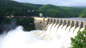
The Srisailam Dam is constructed across the Krishna River on the border of Mahabubnagar District, Telangana and Kurnool district, Andhra Pradesh near Srisailam temple town and is the 2nd largest capacity working hydroelectric station in the country.
The dam was constructed in a deep gorge in the Nallamala Hills in between Mahabubnagar and Kurnool districts, 300 m (980 ft) above sea level. It is 512 m (1,680 ft) long, 145 metres (476 ft) maximum height and has 12 radial crest gates. It has a reservoir of 616 square kilometres (238 sq mi). Project has an estimated live capacity to hold 178.74 Tmcft at its full reservoir level of 885 feet (270 m) MSL. The left bank under ground power station houses 6 x 150 megawatts (200,000 hp) reversible Francis-pump turbines for pumped-storage operation and the right bank semi under ground power station houses 7 x 110 megawatts (150,000 hp) Francis-turbine generators.
Salient Features
| LOCATION: | ||
| State | : | Andhra Pradesh |
| District | : | Border between Kurnool(AP) & Mahaboob Nagar(Telangana)districts |
| Latitude | : | 16-5' N |
| Longitude | : | 78-54' E |
| HYDROLOGY | ||
| Catchment Area | : | 2.06,030 sq km (79,530 sq. miles) |
| Mean Annual Rainfall Maximum | : | 1016 mm (40 inches) |
| Mean Annual Rainfall Minimum | : | 635 mm (25 inches) |
| Design Flood | : | 53770 cumecs(19 lakh cusecs) moderated to 38,365 Cumecs(13,55,680 cusecs) |
| Deep Bed level of River | : | EL 152.4 M (EL 500 ft) |
| Minimum Tail Water Level | : | EL 163.00 M (EL 535.00 ft) |
| Highest Flood Level Observed at Dam site (prior to dam) | : | EL 187.25 m (EL 614.35 ft) |
| DAM: | ||
| Type | : | Gravity Dam |
| Top elevation | : | EL 275.54 M (EL.904.0 ft) |
| Height above the deepest foundation level | : | 143.26 m (470 ft) |
| Total Length at Top | : | 512 m (1680 ft) |
| SPILL WAY: | ||
| Maximum discharging capacity | : | 37,356 cumecs (13,20,00Cuses) |
| Discharging capacity of River Sluices at M.W.L | : | 1009 cumecs (35,680 cusecs) |
| Total Discharging capacity at M.W.L | : | 38,365 cumecs (13,55,680 cusecs) |
| Crest Level of Spill way | : | EL. 252.98 M (EL.830.00 ft) |
| Gross Length of Spill way (between) Faces of training walls | : | 266.39 m (874 ft.) |
| Spill way gates Number | : | 12 Nos. |
| Size | : | 18.3 m x 16.7 m (60'x55') |
| River Sluices Number | : | 2 Nos. |
| Size | : | 3.65m x 9.14 m (12 ft x 30 ft) |
| RESERVOIR: | ||
| Maximum water level | : | 271.88 M (EL. 892 ft) |
| Full Reservoir Level | : | EL. 269.75 M (EL.885 ft.) |
| Gross storage Capacity at F.R.L | : | (215.8070 TMC) |
| Water spread area at F.R.L | : | 541.90 sq. km.(209 sq. Miles) |
| MDDL (for IRR) | : | 260.30 M (854.00 ft) |
| Storage capacity | : | 89.29 TMC (2528.396 MCM) |
| MDDL (for Power) | : | 254.20 M (834.00 ft) |
| Storage capacity | : | 53.851 TMC(1524.871 MCM) |
| Crest level | : | 252.98 M (830.00 ft) |
| Storage capacity | : | 49.49. TMC(1401.387 MCM) |
| Dead Storage | : | 214.875 M (EL 705 ft) |
| Capacity at Dead storage | : | 3.4160 TMC (96.729 MCM) |
| POWER HOUSES | ||
| Right Side Capacity | : | 7 X 110 MW |
| Left Side Capacity | : | 6 X 150 MW |